Beauty of Seven Falls

Sunday, April 29, 2012

Green Mountain Trail, Santa Catalina Mountains in the Coronado National Forest

Our small group of 4 – Stan, Gina, Ernie and me – started out at 7:30 a.m. and made our way through town to the Catalina Highway.  So extraordinary that within an hour or two you can leave town and be out among the ponderosa pine, Douglas fir, and Arizona cypress.  This is a nice short one-way hike which can be done in any season, although spring and fall are the best 
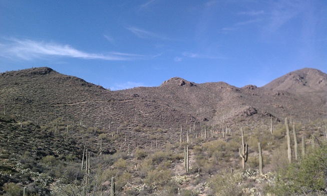
times to do it. The trail goes through different types of forest, and there are very nice views at the upper end. There are also a number of short side trails that you can take.
The Green Mountain Trail starts at over 7,000 feet and winds down about 1,000 to the General Hitchcock campground, the 3.9 mile trail (one way) offers excellent views across the San Pedro Valley.  This hike is a one-way hike where you usually would do a car shuttle to get back to your starting point. Keep in mind… our hikes are becoming more and more abbreviated and modified because of the weather.  We have already had temps of 100 degrees so we have had to alter the normal trails to suit our very selfish need to hike as long as we possibly can.  That being said, we started our hike in reverse, starting at the General Hitchcock campground and climbing up. 
We started out with temperatures a gorgeous 67degrees, 
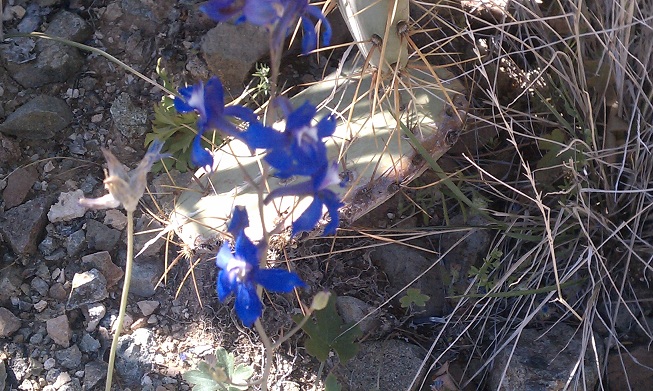
knowing that it wouldn’t be long before they would begin to climb.  The views were absolutely wonderful.  There were hillsides covered with rock formations and thin scrubby forest of pine, oak, manzanita, chaparral and juniper. From some points along the trail we could see Bear Canyon and see Thimble Peak framed at the far end of the canyon. The smell of the pines was amazing, but even more amazing was the sound of the wind blowing through them. 
The group was small and quiet for the most part so we could really enjoy the sounds of nature.  I tried to sing at one point – as I am known to do on hikes – but my song was very short-lived as I was having trouble with the altitude. 
 

We had to make frequent stops because of the altitude.  It wasn’t hot, so we didn’t have to make stops for drinks….it was only because we would become short of breath after the steep climbs.  I say “we” but maybe I should speak for myself.  I am the novice hiker and I am not ashamed to admit when I am out of breath.  The others seemed to be doing fine, but it got harder and harder for me to face another steep incline.  Finally, at about 90 minutes or so in, I felt I was really pushing myself and decided it was time for me to stop.  I offered to stay at this point while the others went ahead to the saddle – our turnaround point (which was actually in view) but the others decided we should stay together as a group.  You have no idea how happy I was at their decision, because I am a big chicken when it comes to lions, tigers, and bears! 
 I don't remember what Stan was teaching us on this one :-(
We took about 20 to 30 minutes to have our lunch before starting back down.  It seemed I picked a really nice spot to give out.  There were some incredible rock formations all around us.  One even looked sort of like a totem pole. 
Thimble Peak
After our light lunch, which did wonders to renew my strength, we started our hike back down to the campground.  Going down was much easier (as usual) than the climb up. We had a wonderful hike, no misadventures, no rattlers, bears, mountain lions or anything.  We were just enjoying each other’s stories and nature’s beauty…..until we reached the end of the trail – the campground – where we were met with a camper in the all-together walking around his campsite.  We weren’t prepared for this much nature, so agreed it was time to call it a day.
Modesty prevents me from posting pictures of the camper....
Oh yes, I would like to take this time to also mention that I didn’t mention any of our group’s unmentionables or wardrobe malfunctions.  lol

Thursday, April 5, 2012

Sweetwater Trail in Saguaro National Park


Me and cactus flower
Well, I’ve been off the trail for several weeks because of personal obligations.  Translation: I had family visiting for a week, I had jury duty the following week, and the third week I was a no account slacker.  That being said, our hikes are dwindling down to a precious few now.  The main group disbanded last week because the temperatures reached way up in the 80s and several people showed signs of heat exhaustion.  We are now operating with a much smaller group and we are abbreviating the length and difficulty of the hikes because of the heat. 


We have decided to gather an hour earlier figuring we can get started earlier and end the hikes before the heat gets dangerous.Whereas our normal hiking group ran between 12 and 18 members per hike, we only had four in our abbreviated group Wednesday.


We left the community center bright and early at 7:30 a.m., which means I was up at 6:00 a.m. so I could walk my dog before starting out. Needless to say….I was not bright eyed or bushy tailed in the least!   

BrickleBush

This week we hiked the Sweetwater Trail in Saguaro National Park in the Tucson Mountains.  We were aiming for the 3.4 mile mark as our turnaround spot.  This point is called Sweetwater Saddle and is the point where the trails from the west side of the park meet the Sweetwater Trail and from here all the trails share the same route to Wasson Peak, the highest point in the Tucson Mountains.   
Jumping Cholla Cactus


We had agreed at onset to hike 1 ½ hours one way, stop for a brief lunch and head back.  We had plenty of breaks to drink water and take pictures.  The scenery was absolutely breathtaking! 

The most notable thing of this hike was the flowers.   The desert was definitely in bloom and we had a wonderful time just trying to identify all of the flowers, cactus, plants and birds along the trail.  There were blossoms of every size and color.   We even took picture of this one cactus flower that looked as if it were coming out of a rock.   
Jorge snapping pics of flowers


This was a most enjoyable hike.  We didn’t quite make it to Sweetwater Saddle before we stopped and turned around, but that’s okay.   We were close enough and we didn’t have any problems – heat or otherwise. 


Me, Connie, Stan and SAGUARO

Hike Statistics (We only did 3 hours, with a break in the middle so we didn’t make the total mileage )

Distance Round Trip 7.36 mile
Trailhead Elevation 2,543 feet
Elevation Gain 412 feet
Accumulated Gain 536 feet
Average Time Round Trip 3.5 hours