Beauty of Seven Falls

Showing posts with label Tucson Mountains. Show all posts

Tuesday, December 16, 2014

Brown Mountain Trail in the Tucson Mountains

Beautiful desert views
We hiked The Brown Mountain Trail on our last outing.   There were 9of us along for the hike, Judy, Ernie, Danielle, Dave, JoAnn, LaNeta, Linda, Kirk, and myself.  We headed out at 8:00 a.m. to perfect weather for hiking – slightly cool and sunny.
Valley views
Alright - starting the climb
The trail is approximately 5 miles long round trip with a 350 ft. elevation gain.  The guidebooks always just give you the highest elevation gain on the trail that you will have to climb.  Sometimes you climb to that elevation more than once.  In the case of the Brown Mountain Trail, it reaches that height a total of 3 times.  It is listed in the guidebooks as a moderate hike and I would have to agree with that. 
Linda, Kirk and LaNeta checking the sights
LaNeta and Joann


Even though we have done this trail before, what keep our hikes fresh and new and exciting are the people.  We have one of the most interesting and diverse group anyone could ever hope for.  Everyone brings different experiences and history to discuss along the trails.
Another new member - Abadaba


We saw many saguaro, prickly pear, and jumping cholla and ocotillo cactus.  There’s not much color out there on the trails this time of year, so any little splash of color gets lots of comments.  One of the best things about the Brown Mountain Trail is the surrounding views.  


We hiked the trail in reverse of how we usually do it.  We stared out at the picnic area and it was pretty level hiking and gradually climbed.  I have to say I think I like this way better.  It probably added another half mile or so to the hike, but not an issue at all.  We seemed to get a different view altogether, and I for one, was not a bit tired by the time we stopped for our lunch break.  It’s always nice to learn new things, even as little as when a well known hike is done a different way.  Thanks Ernie! 
Happy hiker - happy cactus!
Ernie leading the way


That Cougar Trail sign is always getting people in trouble!
Judy
 

Abadaba
Lunch break - one of my favorite parts of the hike....
Except when Abadaba swipes my PB&J

Scenic mountain views....

One of many saguaros we saw with twisted arms

This one seems especially happy to see us

Another wonderful hike under our camelbacks!  Can't wait til the next one.

Exhaustion sets in
See you on the trails....

Friday, March 22, 2013

Wasson Peak in the Tucson Mountains

Our goal in the distance...

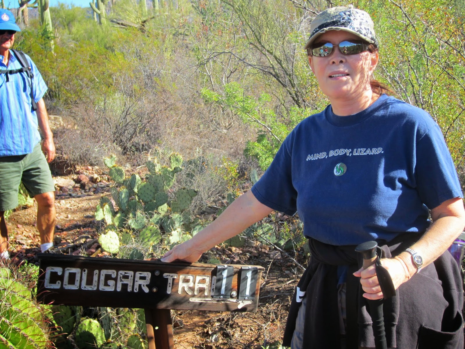
Our hike this week took us to the Tucson Mountains to have a try at Wasson Peak (elevation 4,687 feet), the highest point in the Tucson Mountains.  I must admit right here and now that being the novice hiker, I was extremely apprehensive about this hike.  In the year since I joined our neighborhood hiking group, I had heard many times about Wasson Peak from my fellow hikers.  Many of them mentioned with pride having scaled to the top of Wasson Peak and some in the group had even pointed out the peak to me when we were on various other hikes in the Tucson Mountains.  I had pretty much talked myself out of trying the hike when it was described as difficult.  I even had a chance to opt out of even trying because we scheduled 2 hikes for this week; one hike would include the entire group following the Sendero Esperanza Trail until we crossed the Hugh Norris Trail.  At the saddle, part of the group, because of previous obligations,  would turn back around and return to the trailhead, making that hike a total of 4 miles round trip. The rest of the group would continue on the Hugh Norris Trail to Wasson Peak.  The total for this group would be 8 miles and 1,700 feet elevation gain.  I decided on the longer hike…I felt I could at least try.  I mean, nothing ventured – nothing gained right?  I could always sit at any point along the trail and wait for the others to come back and join them on the way back down.
Off we go, with Gordy bringing up the rear
We left our usual meeting place a little earlier in anticipation of the hike taking more time.  The weather was cool and overcast – perfect for hiking.  It only took us about 30 minutes to reach the trailhead and get started.


The first part of the trail is the sandy path of an old mine road.  I must mention that walking on sand that is gradually climbing in hiking boots is not the same as being barefoot at the beach.  It was along this sandy path that we came across the largest jackrabbit I had ever seen. It is also called a desert hare, but looked like a small deer to me.  Does anybody remember Twilight Zone the Movie?  Remember the segment with the little boy that could make things happen just by thinking them?  They were having a magic show and he had this one guy pull a rabbit out of a hat.  When he pulled the rabbit out, it was this huge, mutant, monster looking rabbit.  That’s what I thought of when we saw this rabbit. I am posting a picture from Wikipedia just as a point of information - I did not take this photo.  He was much too fast for me.  

Wikipedia photo
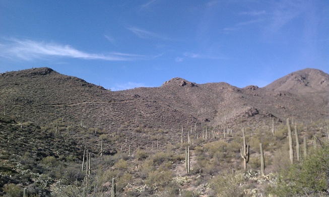
 We were really ready for the next part of the trail which is where we started climbing a series of switchbacks to the top of the ridge where it crosses the Hugh Norris Trail.  We gained about 600 feet on this first leg of 
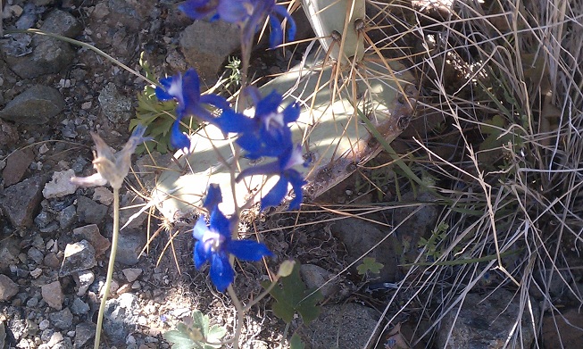
our journey.  We were greeted with quite an array of wildflowers and of course the stately saguaro cactus forest. 


When we reached the third of several saddles along the Hugh Norris, half of our group turned back.  We said our goodbyes and continued along the ridge through areas with magnificent views.  I noticed that there weren’t as many saguaro cacti as we climbed higher.  There was more grass and different cactus such as ocotillo, prickly pear, mesquite, cat’s claws and of course my least favorite cactus the cholla.  


JoAnn and Gina leading on 
LaNeta, Gordy and Ernie going back


I was getting pretty winded as we continued our climb.  Jim took over as lead hiker with Gina right on his heels.  JoAnn and I brought up the rear.  I know that I mentioned more than once that I was tired.  JoAnn even agreed with me once.  We were getting close though….no turning back or stopping now….I had to push on.

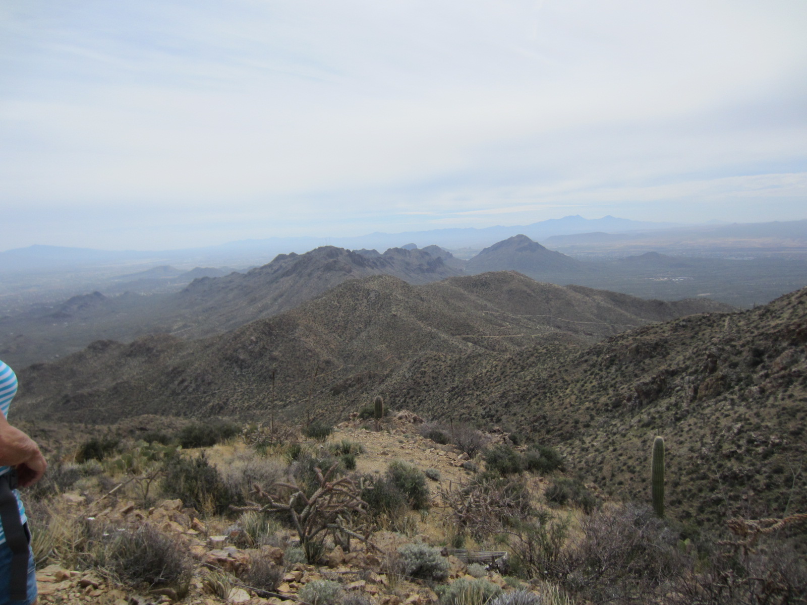
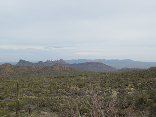
We finally reached the summit and even though it was very overcast, we were able to see Brown Mountain and Golden Gate Mountain to the south, and the Rincon and Santa Catalina ranges to the east.  I had made it!  The novice hiker should at the very least be considered an intermediate hiker now.  The feeling of accomplishment is indescribable.  I really thank my group for putting up with all my whining and complaining for the past months, and for getting me to a point where I really feel proud of myself.  Love you guys!

Views from the top!


Jim and Gina waiting for JoAnn to sign the register

Much needed rest and lunch break

It was really worth the climb


Look at me Ma!  Top of the world!
See you on the trails.....


Friday, January 18, 2013

Saguaro National Park West

Beautiful view of mist in the mountains 
Our hike this week took us to beautiful Saguaro National Park West in the Tucson Mountains.  Ten enthusiastic, overly bundled hikers (our temperatures here in Tucson had been below normal for 4 days and we had no idea what to expect up on the trails) met at the community center and started out at 8:30.  The weather was a little chilly, but beautiful Arizona sun did not let us down.  The morning was gorgeous. 

We got off to what we thought was a good start when JoAnn realized she had not placed her park pass on her windshield for the park rangers.  Not a huge problem because we had good old Jim to run - and I do mean run - back to the parking lot to put it in place. 
Run Jim, Run
We began our morning at the King Canyon Trailhead heading for the Gould Mine.  The Gould Mine was one of four mines of some consequence in the Tucson Mountains: Old Yuma, Gila Monster, Mile Wide, and Gould mines.  Sometime around 1906 S.H. Gould filed on nineteen claims for the Gould Copper Mining Company. As was the case with other mining companies, Gould encountered financial problems with the onset of the 1907 depression, but he succeeded in obtaining operating funds by taking a mortgage with the Pioneer Smelting Company from nearby Sasco. A thirty-five foot wide vein of copper was found at the 100 foot level. At the 200 foot level that vein broadened to a width of sixty feet. Unfortunately, an assay reported only three to four percent copper content in each ton of ore. Financial difficulty beset the Gould Company by the end of 1908 and it managed to survive only for a few more years by shipping excavated ore which had been stockpiled at the mine. It probably ceased operations sometime in 1911. In early 1915 the company was forced into bankruptcy and its claims were sold at a sheriff's auction. They were purchased by Douglas Gary of Tombstone who made no immediate attempt to operate the mine. For all the effort and investment only 45,000 pounds of copper with a value of $9,000 had been taken from the mine.

Copper mine desperadoes - LaNeta, Connie, Gina & me
We were able to see what was left of some of the buildings used for storage and shelter.  

JoAnn & Jim surveying the mine entrance


So how much barbed wire is needed?


There were barbed wire fences surrounding dangerous areas, such as the actual mine entrance, but of course that was meant for everyone except our adventurous Jim who spotted ringtail raccoons down in the shaft.

It took quite a hike to get to the mine and I was wondering if the men had to hike up to the mine every day or if they camped at the mine.  I found one picture online which showed the mining camp and it seemed to be at the base, not near the mine. 

Oh well, on with the hike….
Hi Ho Hi Ho it's on the trail we go....
I sometimes get caught up in the historic significance of the area, and fail to mention the beauty of what we see as we are hiking through the park.  The saguaro cactus that sometimes tower above us so high I can’t even figure out how to get the whole thing in the photos.  My good friend George told me last week, that I need a bigger camera.  L  Along trail we saw many different types of cactus, and we noticed a family of javelina on a lower trail from us.  Thank goodness, they were also downwind. 

Gordy measuring up to a saguaro - he lost
We proceeded from the mine past the Mam-A-Gah picnic area to the Sendero Esperanza Trail and from there to the Hugh Norris Trail.  The maps our leader JoAnn gets from the National Park Service are usually pretty accurate as far as the mileage of the trails and the elevation gain on each hike, but we had varying opinions on the distance of this one.  We all felt the total hike was more like 5 ½ or 6 miles rather than the 4+ miles the map was telling us.  Several of the group actually stayed behind when we stopped to take water and rest a little.  Being the novice hiker, I always push myself to keep up, so I made it to the saddle we were aiming for as a turn-around point.  I tell you, I was very glad that the trip back would be mainly downhill though.  OUCH!  My legs…. Anyway, enough with the whining! What are we hikers or cry-babies?  We made it to the saddle, and then doubled back, picked up the couple of people that had waited at the bottom, and trekked back to the Mam-A-Gah picnic area for MY favorite part of the hike….lunch.   
If you look real closely...saguaro are the supports 
After lunch, JoAnn located a shortcut that took us past a huge wash that probably looks more like a lake during monsoon season.  We didn't go into the wash, but those in the group that had been on this particular hike previously mentioned that there are petroglyphs on rocks along the wash.  It is just amazing that when you least expected - a petroglyph pops up.  Kind of like when my kids were young and their friends always seemed to show up right at dinner time.... Well, this hike was fantastic.  Wonderful weather, no mishaps, a lot of history and great fellowship.  

We retraced our steps past Gould Mine and took the loop trail back to the parking lot.  The total mileage again in question.  Boy, that hot tub is going to look good this evening.
Judy and Barb doing a few wardrobe adjustments?

See you on the trails!


Thursday, April 5, 2012

Sweetwater Trail in Saguaro National Park


Me and cactus flower
Well, I’ve been off the trail for several weeks because of personal obligations.  Translation: I had family visiting for a week, I had jury duty the following week, and the third week I was a no account slacker.  That being said, our hikes are dwindling down to a precious few now.  The main group disbanded last week because the temperatures reached way up in the 80s and several people showed signs of heat exhaustion.  We are now operating with a much smaller group and we are abbreviating the length and difficulty of the hikes because of the heat. 


We have decided to gather an hour earlier figuring we can get started earlier and end the hikes before the heat gets dangerous.Whereas our normal hiking group ran between 12 and 18 members per hike, we only had four in our abbreviated group Wednesday.


We left the community center bright and early at 7:30 a.m., which means I was up at 6:00 a.m. so I could walk my dog before starting out. Needless to say….I was not bright eyed or bushy tailed in the least!   

BrickleBush

This week we hiked the Sweetwater Trail in Saguaro National Park in the Tucson Mountains.  We were aiming for the 3.4 mile mark as our turnaround spot.  This point is called Sweetwater Saddle and is the point where the trails from the west side of the park meet the Sweetwater Trail and from here all the trails share the same route to Wasson Peak, the highest point in the Tucson Mountains.   
Jumping Cholla Cactus


We had agreed at onset to hike 1 ½ hours one way, stop for a brief lunch and head back.  We had plenty of breaks to drink water and take pictures.  The scenery was absolutely breathtaking! 

The most notable thing of this hike was the flowers.   The desert was definitely in bloom and we had a wonderful time just trying to identify all of the flowers, cactus, plants and birds along the trail.  There were blossoms of every size and color.   We even took picture of this one cactus flower that looked as if it were coming out of a rock.   
Jorge snapping pics of flowers


This was a most enjoyable hike.  We didn’t quite make it to Sweetwater Saddle before we stopped and turned around, but that’s okay.   We were close enough and we didn’t have any problems – heat or otherwise. 


Me, Connie, Stan and SAGUARO

Hike Statistics (We only did 3 hours, with a break in the middle so we didn’t make the total mileage )

Distance Round Trip 7.36 mile
Trailhead Elevation 2,543 feet
Elevation Gain 412 feet
Accumulated Gain 536 feet
Average Time Round Trip 3.5 hours