Beauty of Seven Falls

Thursday, April 4, 2013

Safford Peak, also called Sombrero Peak


Our goal

Gina & Connie
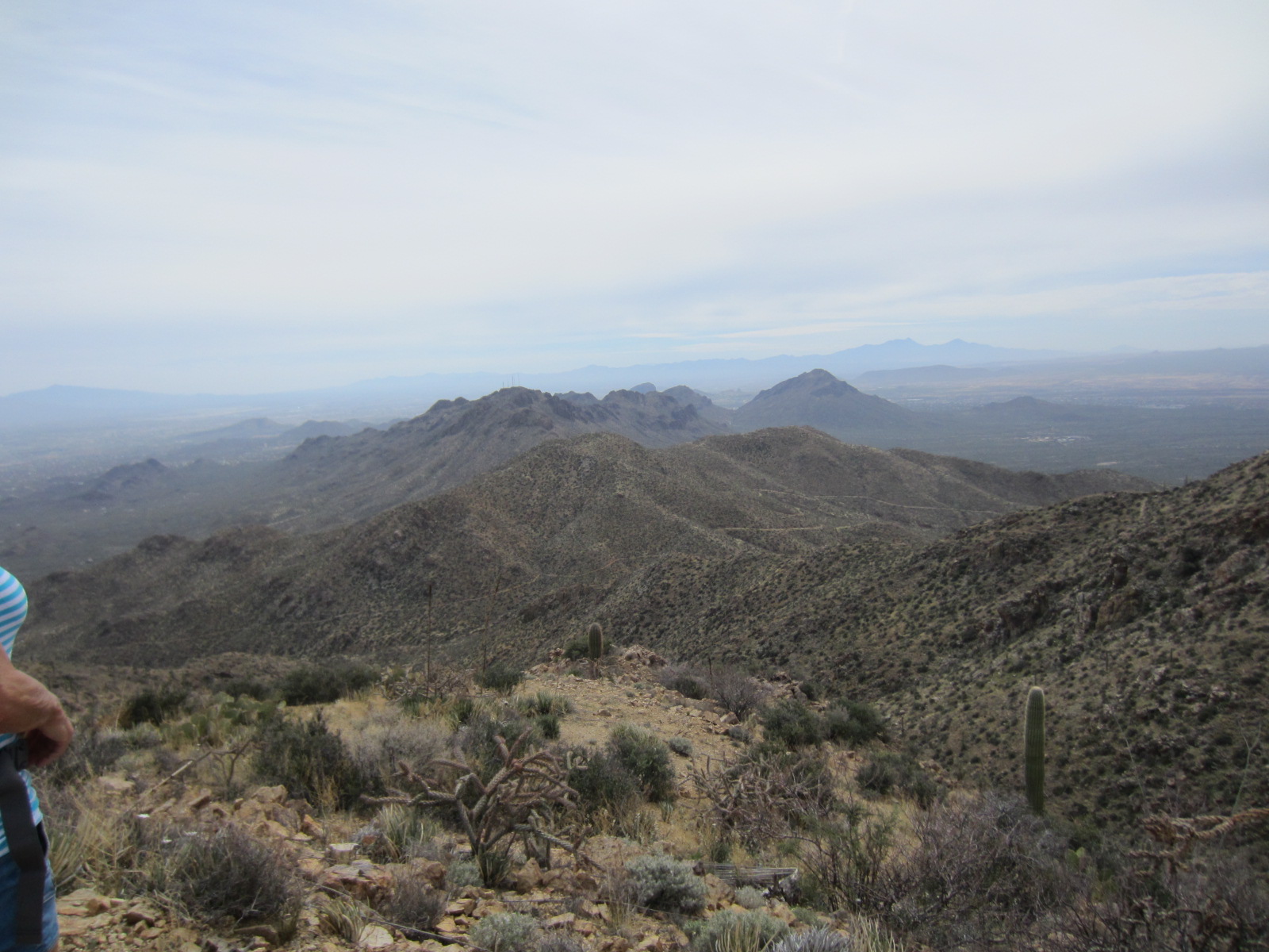
Our hiking time is dwindling down because of the desert heating up, so we have to make every outing count.  JoAnn decided to keep it close to home again this week to cut down on travel time so we could finish before the sun got too hot.  Safford Peak, affectionately called Sombrero Peak by the locals because of the shape of the top peak is a fixture of the Tucson countryside.  Located right here in Marana, AZ just down the road about 15 minutes from our homes, it was one of the landmarks that helped me find my way around town when I first moved here in 2010.  It seemed no matter where I traveled around town shopping – I could always find my way back home, even without GPS by getting Sombrero Peak in my sights. 
Very deadly sun
Mike's look - priceless 
We had a pretty good size group again this week, a total of nine.  We started out at 8:30 and were there at the trailhead before 9:00.  We had beautiful blue skies, but could tell that it was going to heat up very quickly.   Sombrero Peak is part of Saguaro National Park and although there is no marked and developed trail leading up to the top, hikers can use unmarked and unimproved tracks.  JoAnn and several other members of the group had hiked these trails before and felt very comfortable following the paths (I feel very comfortable following her).
JoAnn, Gina and Barbara

Brittlebush in bloom
We started out pretty on pretty level ground, enjoying the wildflowers that were blooming, the ever present cacti, and even a bunny or two.  Someone had mentioned early on the hike – I think it was Gina – that she had warned that this area was known as being infested with rattlesnakes, so we made sure we kept our eyes peeled along the trail.  We tell the trail started to climb within about ½ mile or so and was a pretty steady climb going forward.  The ground was covered with very loose, rocky ground.  We had to really take our time and choose our footing carefully.  
 
Rolling Rocks
We followed several different trails as we started our climb.  JoAnn had been on this trail recently and was aware of one detour that would lead us to a scenic lookout.  We all voted to take the detour, because not only are we out there for adventure and exercise, we are also out there to enjoy the beautiful views. 
 As I mentioned earlier, there are no official trails, but there is something to follow the whole way – you can almost always get sight of the chapel called Sanctuary Cove.
I personally would not call this hike “easy” because of the challenge of keeping your feet under you.  There were several saddles as we climbed up, I am not really sure if there were 2 or 3 before we started back down.  I do know that there were some wonderful views of Marana down below us.  We had fun trying to pick out the grocery stores, the interstate, and several main roads through town. 
 
Sombrero in our sights!

Ever winding trail up.....
Well, it wouldn't be much of an adventure if someone didn't fall, get stabbed by cholla cactus or fall in a stream, so here it is….
On the way back down, the rolling rocks were especially hard to navigate and several of us lost our footing completely and took tumbles.  I never even saw it coming when it was my turn.  
Difficult footing

We had to help each other down
While I was climbing down, I hit loose gravel and my left foot shot forward while my right leg bent underneath me.  It looked kind of like a wannabe cheerleader cheating while doing a split.  It was a half-split and not even a graceful one with arms up in the air.  My granddaughter who was a cheerleader for many years would have been ashamed of me.  Anyway, no skinned hands or knees and no broken bones so all in all a pretty uneventful fall.  I only wish someone was close enough to grab my camera and get a shot of it.  I think I should also mention at this point that we did not go clear to the top of the peak.  That is a very dangerous climb like climbing rock face and since it is not a marked trail in a national park, it is basically an illegal hike.  We keep our hikes legal and above board.  lol
George next to an ocotillo in bloom 
Views of our neighborhood below

Beautiful views.....


Hedgehog in bloom
I think I will miss the camaraderie more than anything else once we hang up our hiking boots and poles for the season.  We enjoy each other’s company and stories of family and friends back home.  All of the conversations make the hike go easier and before we know it, we were back on level ground heading for the chapel where we were going to eat a quick lunch before heading home.  There is a shady picnic area, but we ate at the amphitheater where they sometimes hold services.

Having our lunch behind the chapel.  
Now, I don’t want to give anyone the wrong idea about our group, but this hike ended up at our new member, Mike’s home.  Mike makes homemade beer and had offered to let the guys sample his wares.  Well, we all piled into our vehicles and traveled the few minutes to Mike’s.  I am not really a beer drinker, but he got thumbs up all around and I think George and Jim were trying to talk him into bringing his brew to the potluck being planned for a couple of weeks down the road.
When I got home I noticed my knee was very stiff and starting to swell.  I put ice on it for about 45 minutes and once it returned to normal temperature, I jumped into the hot tub.  It was a perfect end to another perfect hike.

See you on the trails.....

Thursday, March 28, 2013

Picture Rocks in the Tucson Mountains


Our hike this week took us to the Tucson Mountains once again.  We were back in the beautiful Saguaro National Park.  This time we would do a loop of several connecting trails including the Picture Rocks Wash Trail, Ironwood Trail, and Cam Boh Trail.  The total hike would be approximately 4.5 to 5 miles.  Our group of 7 started out at our regular time and reached the trailhead in about 20 minutes.  This is one of our close-to-home hikes.  We don’t get a lot of elevation with these, but it is nice to get to our destination very quickly. 
Starting out - Jim, Judy, Connie, Barbara, Bonnie, & Barbara
It was a warm morning and we were eager to get started because temperatures seem to climb very quickly in the afternoon in the direct sun.  Today was to be no exception.  We were sorry not to have LaNeta and Gordy who have gone home to North Dakota for the spring and summer, but we were very happy to have Connie, who has been on sick leave (can you be on sick leave from a hiking group?) back with us.  We chatted along the Picture Rocks Wash, in which the sand almost seems like quicksand at times.  I don’t know which is harder – climbing up higher elevations, or trudging through sand.  I do know I have come to prefer the climbing…just a personal aside. 
Long-horn sheep or goat?
Hunters?


Not too far into the wash we came upon the rocks that are famous for the petroglyphs that are carved into them.  I have seen the rocks on previous hikes, but they never cease to amaze me.  They were carved by Native Americans, probably Hohokam, hundreds of years ago, and have endured here in the Sonoran desert.  I always try to figure out what type of animal they were carving, and what they were trying to convey.  Some think that they were probably carved as part of a pre-hunt ritual.   They are always interesting to see.  


This hike is one that really lets you know you are in the desert.  All you see are cactus, sand, cactus, rocks, desert blooms such as chicory and poppies, cactus, lizards, and did I mention cactus?  Not to worry about it not being scenic though, there are always the ever present surrounding mountain views. 

Mountain views

More mounts

Still more beauty
We reached the halfway point very early, about 11:00 and decided we would stop here for our lunch.  There was a shady little alcove where all 7 of us could enjoy a few cool moments out of the sun.  This little alcove is just indicative of the quiet and serenity of this area.  This trail is actually carved out and around a religious retreat called Redemptorist Renewal Center.  People come from far and near to enjoy the solitude and reflection.
 
Jim, Barb, Connie and Judy

Connie and Judy

One of these things just doesn't belong here....

All the Ladies
After lunch we continued on our way making a loop back to our starting point.  I can say that this is one of the easier hikes, but very enjoyable for all. 

Hi Ho Hi Ho, back down the trail we go


See you on the trails.....

Friday, March 22, 2013

Wasson Peak in the Tucson Mountains

Our goal in the distance...

Our hike this week took us to the Tucson Mountains to have a try at Wasson Peak (elevation 4,687 feet), the highest point in the Tucson Mountains.  I must admit right here and now that being the novice hiker, I was extremely apprehensive about this hike.  In the year since I joined our neighborhood hiking group, I had heard many times about Wasson Peak from my fellow hikers.  Many of them mentioned with pride having scaled to the top of Wasson Peak and some in the group had even pointed out the peak to me when we were on various other hikes in the Tucson Mountains.  I had pretty much talked myself out of trying the hike when it was described as difficult.  I even had a chance to opt out of even trying because we scheduled 2 hikes for this week; one hike would include the entire group following the Sendero Esperanza Trail until we crossed the Hugh Norris Trail.  At the saddle, part of the group, because of previous obligations,  would turn back around and return to the trailhead, making that hike a total of 4 miles round trip. The rest of the group would continue on the Hugh Norris Trail to Wasson Peak.  The total for this group would be 8 miles and 1,700 feet elevation gain.  I decided on the longer hike…I felt I could at least try.  I mean, nothing ventured – nothing gained right?  I could always sit at any point along the trail and wait for the others to come back and join them on the way back down.
Off we go, with Gordy bringing up the rear
We left our usual meeting place a little earlier in anticipation of the hike taking more time.  The weather was cool and overcast – perfect for hiking.  It only took us about 30 minutes to reach the trailhead and get started.


The first part of the trail is the sandy path of an old mine road.  I must mention that walking on sand that is gradually climbing in hiking boots is not the same as being barefoot at the beach.  It was along this sandy path that we came across the largest jackrabbit I had ever seen. It is also called a desert hare, but looked like a small deer to me.  Does anybody remember Twilight Zone the Movie?  Remember the segment with the little boy that could make things happen just by thinking them?  They were having a magic show and he had this one guy pull a rabbit out of a hat.  When he pulled the rabbit out, it was this huge, mutant, monster looking rabbit.  That’s what I thought of when we saw this rabbit. I am posting a picture from Wikipedia just as a point of information - I did not take this photo.  He was much too fast for me.  

Wikipedia photo
 We were really ready for the next part of the trail which is where we started climbing a series of switchbacks to the top of the ridge where it crosses the Hugh Norris Trail.  We gained about 600 feet on this first leg of our journey.  We were greeted with quite an array of wildflowers and of course the stately saguaro cactus forest. 


When we reached the third of several saddles along the Hugh Norris, half of our group turned back.  We said our goodbyes and continued along the ridge through areas with magnificent views.  I noticed that there weren’t as many saguaro cacti as we climbed higher.  There was more grass and different cactus such as ocotillo, prickly pear, mesquite, cat’s claws and of course my least favorite cactus the cholla.  


JoAnn and Gina leading on 
LaNeta, Gordy and Ernie going back


I was getting pretty winded as we continued our climb.  Jim took over as lead hiker with Gina right on his heels.  JoAnn and I brought up the rear.  I know that I mentioned more than once that I was tired.  JoAnn even agreed with me once.  We were getting close though….no turning back or stopping now….I had to push on.

We finally reached the summit and even though it was very overcast, we were able to see Brown Mountain and Golden Gate Mountain to the south, and the Rincon and Santa Catalina ranges to the east.  I had made it!  The novice hiker should at the very least be considered an intermediate hiker now.  The feeling of accomplishment is indescribable.  I really thank my group for putting up with all my whining and complaining for the past months, and for getting me to a point where I really feel proud of myself.  Love you guys!

Views from the top!


Jim and Gina waiting for JoAnn to sign the register

Much needed rest and lunch break

It was really worth the climb


Look at me Ma!  Top of the world!
See you on the trails.....


Saturday, March 16, 2013

Return to Parker Canyon Lake in the Coronado National Forest

Beautiful and serene
I knew this was going to be a wonderful hike when I got up in the morning and came into the kitchen to start the coffee.  I opened my blinds and a red-tailed hawk flew onto my roof.  He crooked his head to one side as if to say “Are you ready? Let’s go”.  I told my fellow hikers that we were hiking like the ancient Native Americans, with the spirit of the hawk along with us.  Who says I have no imagination?  
Hawk is ready to lead the hike

Santa and elves fishing
Our hike this week was a return to Parker Canyon Lake.  If you remember our experience last year – the sudden rain and wind storm- this one was the exact opposite.  We were a small group – only 6 – and we started out a little bit earlier because of the distance we had to travel to the lake.  The drive is about 100 miles from Marana, AZ and took us just about 2 hours to arrive there.  The weather seems to always cooperate with our group and this day was no exception.  We arrived to blue skies and calm breezes, and several fishermen already with lines in the water.

Most people would say this hike is easy to moderate and I would tend to agree.  It is about 5 miles and the trail around the lake usually is a fairly level dirt pathway that, for the most part, stays within a few yards of the water.  We found the trail hard to follow at times because it seems it hasn’t been very traveled so far this season.  Maybe this is due to the rental of canoes, kayaks and paddleboats this season. 

Family canoeing & fishing
There were quite a few groups out enjoying the lake – boating, fishing, camping and of course hiking.  We thought it was probably because some schools were already celebrating spring break.

The lake looks small but as in many things – looks can be deceiving.  When you start the hike you can see less than half of lake and the size of the lake and the length of the hike are surprising because of the numerous inlets you continuously navigate adding to the coastline.  

One of many inlets
JoAnn - pointing the way
This is another one of those hikes that make me extremely thankful for our leader, JoAnn.  She has been on most of these hikes over the years and has a pretty good idea of the trails and which way to go, even when they are not clearly marked. 

Parker Canyon Lake is a beautiful 130-acre lake, the largest lake in the Coronado National Forest.   It is host to many wading birds, wintering eagles, and we were lucky enough to see a great grey heron soaring across the lake.  The lake was created in 1966 when the Arizona Game and Fish Department completed construction of an earthen dam at the junction of Parker Canyon, Collins Canyon, and Merritt Canyon in Canelo Hills southeast of Sonoita.  It is located just six miles north of the Mexico border. 

Ever have the feeling you were being watched?  lol

The "floating eye" in the sky
This would probably be a good time to mention "the blimp".  In the summer of 2012, the U.S. military started bringing back dozens of surveillance blimps from the battlefields of Afghanistan.  The 72-foot-long, unmanned surveillance blimp—sometimes called "the floating eye" when used to spot insurgents in Afghanistan—can help find drug runners and people trying to cross illegally into the U.S.  We had extremely good views of the blimp from the lake.  
Gordy, LaNita, Val, JoAnn and Judy
This was a very enjoyable hike.  We were able to take our time and really enjoy the scenery because there wasn't a lot of loose rocks or major climbing like some of the other trails.  


As always - we enjoyed beautiful views of the surrounding landscape and bonus - we visited one of the local wineries at the completion of the hike. Just as this was a return trip to Parker Canyon Lake, we revisited the Kief-Joshua Winery.  


It was very exciting because not only to they have the largest bloodhound I have ever seen, they also have sheep and goats and believe it or not - a wallaby!  This in itself is probably not that big of a deal, but one of the sheep had had a little baby just that morning, so going out and visiting with the new mother and baby was more interesting I think than finding out about the winery.  

Baby nursing
The baby didn't seem to be getting any milk - like we're all experts in the field right?  Anyway, we went in and got the owner and his wife and they came out and actually lay the ewe down (not an easy job) and held her down so the baby could nurse.  All very interesting.

Hikers - nursing their wine?

                   
That was one big hound dog!
I was telling him a secret....


A Wallaby!!!!


Stay thirsty my friend.  No that's not it.... 

Oh Yes!  I remember now...

See you on the trails...